
Embrace the Virgin Machhapuchhre
The MMBC (Mardi and Machhapuchhre Base Camp) trek is another milestone in developing mountain tourism in Nepal. Mardi Himal Base Camp and Machhapuchhre Base Camp are at the same place, and both mountains have uniquely distinct stories.
Actually, Mardi Himal 5,587m has two base camps, one is to the west of it, which is known as Mardi Himal Trek, but from this side it is almost impossible to climb the peak. Along the route to the peak, there are many ascents and huge slide-able rocks. So south-east base camp or Machhapuchhre south base camp is the more suitable point from which to climb it.
Machhapuchhre (Fish-tail) (6,993m-6,997m) is a mountain on whose summit no human has ever set foot. The only attempt was in 1957 by a British expedition team led by Lieutenant Colonel Jimmy Roberts and his fellow climbing members Wilfrid Noyce and A. D. M. Cox. They climbed to within 150 meters (492 ft) of the summit via the north ridge, to an approximate altitude of 6,847m. Since then the mountain has been declared sacred and is now closed to climbers.
From the south base camp of Machhapuchhre, you have a close view and can see its sharp tip. And if you climb a few minutes to the end of thegrassy slope, you then see the deep glacial narrow gorge,which is the source of one of the 2 Seti tributaries. The southern base camp of Machhapuchhre is very different from the west base camp along the ABC trek. It’s located at an altitude of 4,403 meters. The views you see in the wide range include Mardi Himal, all of Machhapuchhre, huge cliffs, the Buddha Himal, gorgeous landscapes and an ocean of cloud to the south. If you visit here in monsoon, you can observe hundreds of types of special flora and fauna.
May be you dared to extend your challenging hike to the confluence of the Seti and its 2 tributaries (Madi and Modi) or the main sources of those 3 Rivers that flow from Annapurna III, IV and Machhapuchhre. Pawan Magar and I didn’t continue after the view point ridge. According to the local people of Ghachok and Lachok, on the way to the Seti and its 2 tributaries, there is a place called Annapurna; there you see piles of sand like piles of rice. If you leave these scattered piles of sand, after a few hours or the next day, you will see all these piles of sand just as before. According to legend, this is why the place is called Annapurna. Soon you reach the southern base camp of Annapurna III, IV and Machhapuchhre eastern base camp.
Machhapuchhre Virgin trek requires 90% camping. The best seasons are October to November and March to May. You can start and end it at Karuwa and Ghachok or Saidighatta. Most parts of this trail are confusing and difficult to find. Pawan and I walked via west base camp to south-east base camp of Mardi Himal or Machhapuchhre south base camp and returned via Korcha Danda and Saidighatta and drove to Pokhara.
The walk between Bunkha Kharka and Korcha Danda (Korchung) is along a razor edge trail with 360 degree views! We were told when the weather is clear, everyone gets emotionally touched by the majestic Himalayas and mysterious landscape scenery.
Along most of this trail there are problemsin finding drinking water. For some camps you will have to carry it with you or hire a local expert to find it. Machhapuchhre Model Trek Management Committee (MMTMC) and Machhapuchhre Paryatan Bikas Samiti (MPBS) are led by Mr. Basanta Dawadi, Mr. Bhakta Gurung (chair persons) and Mr. Kul Prasad Adhikari (secretary). Their team is involved in developing alternative trekking routes and community based village tourism.
This trek would be the best choice for adventurers and nature lovers. Anyone wanting to know more about it can contact us by E-mail or theWhatsApp numbers we have provided. This trip is a 14-day round trip from Kathmandu.
Pokhara to Mardi Himal West Base Camp (4,225m).
Here, I want to briefly describe Mardi Himal west base camp because there are many changes. You can also read a detailed description of it on my blog-site:www.trekwithpremrai.com.
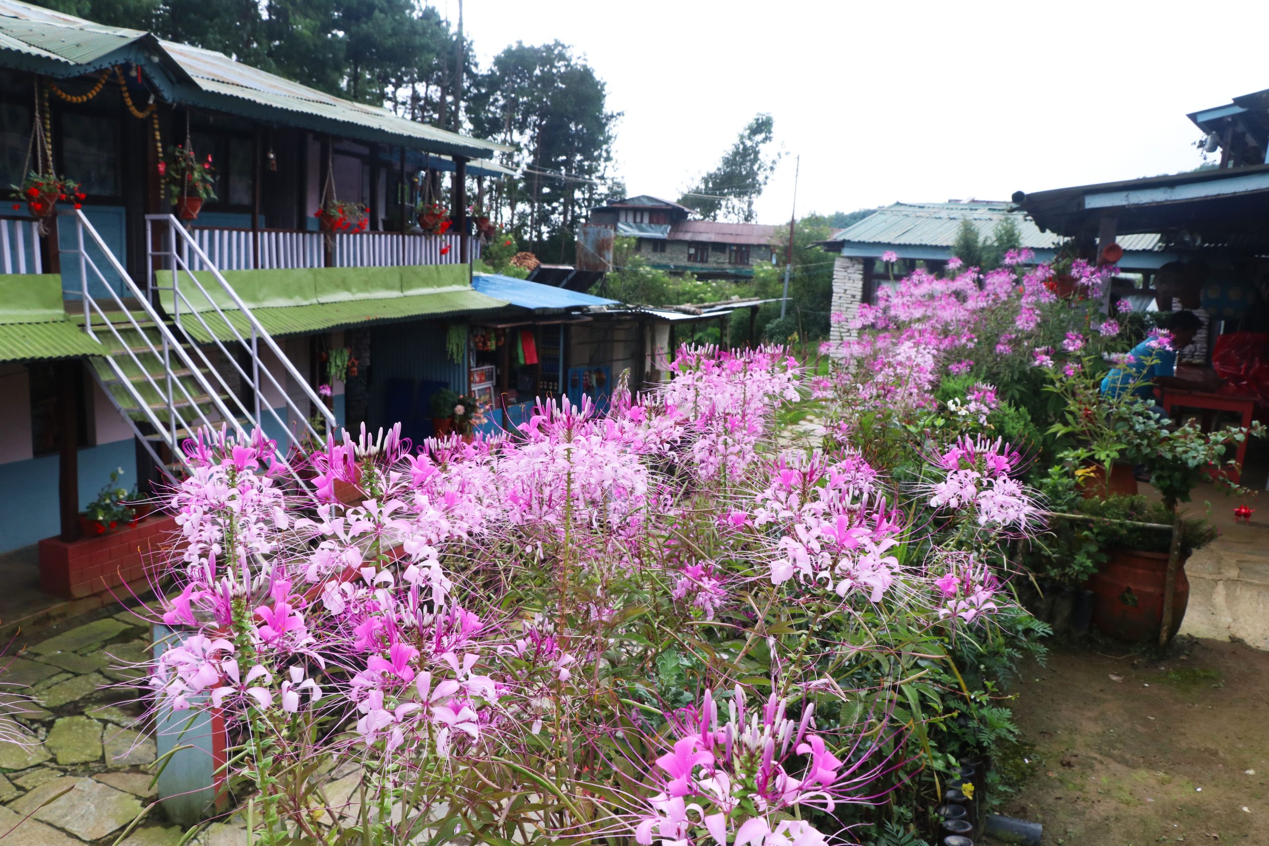
Drive from Pokhara to Kande in 1 hour. The trek starts from here and goes on through Australian Camp, Pathana and Pitam Deurali. Here turn right and gently climb for 15-20 min to Syamje Kharka, where there is a newly built guest house.
Now, you have two options: you can go right and follow the old trail which has more climbing; or you can take the newly made left trail to Gaikharka Gauda 35-40 min. This has one guest house. After another 30-40 min walk to Panikhalta (little pond) you reconnect with the old trail.
You have an easy 40 min trek to Dund Kharka (2,500m), where there is a tea shop. Here a junction leads right to Ghalel and Lwang and left to Forest Camp. Continue on 40 min flat (by Nepali standards) to Musalbari and a tea shop. Reaching the Landruk trail junction takes another 35 min, and soon you arrive at Forest Camp where there are many lodges. Then it’s a 45 min climb to Rest Camp with a big guest house. Continue climbing for about 2½-3 hrs in dense forest to Low Camp at 2,956m. Here there are at least 10 lodges. Returning back from here, you can descend directly to Siding and take a vehicle to Pokhara. Now, it’s about 50 min tough climb to Middle Camp (3,178m).
Here after a little descent and then a 20 min climb you reach Badaldanda (3,248m) where are already 5 lodges. If the weather is clear, you get incredible views. It’s 25 min to lower High Camp at 3,360m, where there is one lodge to stay. A 1-hour climb along the high ridge trail takes you to High Camp (3,550m). At High Camp you have a choice of several lodges.
25 min further on from High Camp, there is a trail junction at the bottom of a high hill. Going left over a big cliff trail is possible if you are fit and takes 25 min, but turning right and going round it in about 40 min (3,668m) is safer. Keep on climbing for 1¼ hrs to Ekle Deurali (4,003m). Here we paid a visit to a tea shop under construction.
In 45 min, you reach some century-old graveyards (4,061m). The people of Siding told us an interesting story about it and we also clearly saw an inscription plate and graves around. In the past hundreds of pilgrim made their special pilgrimage visits to Machhapuchhre Pujinam Barah and other religious mountain shrines. No woman is allowed to visit here during menstruation, but one woman pilgrim did this. Because of this more than 17 pilgrims were killed by a thunderbolt.
After climbing 20 min you come to a chorten(4,121m). Then in the next 15-20 min, you reach Upper View Point (4,153m), and finally climb to Mardi Himal west base camp (4,225m) (The sign post says 4,500m, but my Garmin 64st only shows 4,225m). When the weather is good, the views are stunning.
Mardi Himal West Base Camp to Thulo Bukeni Pass (4,361m) (about 7-8 hrs.)
At this base camp you turn right and continue on a very difficult walk for about 3 hrs on the grassy steep to cross a stream and alandslide area (4,330m). Then, you descend for1 hour to the icefall, cross it and have a hard climb for a few hundred meters. Then turn right and walk 2-3 hrs to come to a rocky place, covered with large boulders. From here turn slightly left and have a 1 hour steady climb up to the pass of Thulo Bukeni (4,361m). You get a splendid view of Buddha Himal, Annapurna II, Machhapuchhre, Annapurna South and much more on a clear day. The people of Saidighatta and Siding are even thinking of making ropeways on this part to connect both base camps. You should not attempt this without an expert guide.
Thulo Bukeni Pass to Nauche Kharka (4,317m; 3hrs approx.)
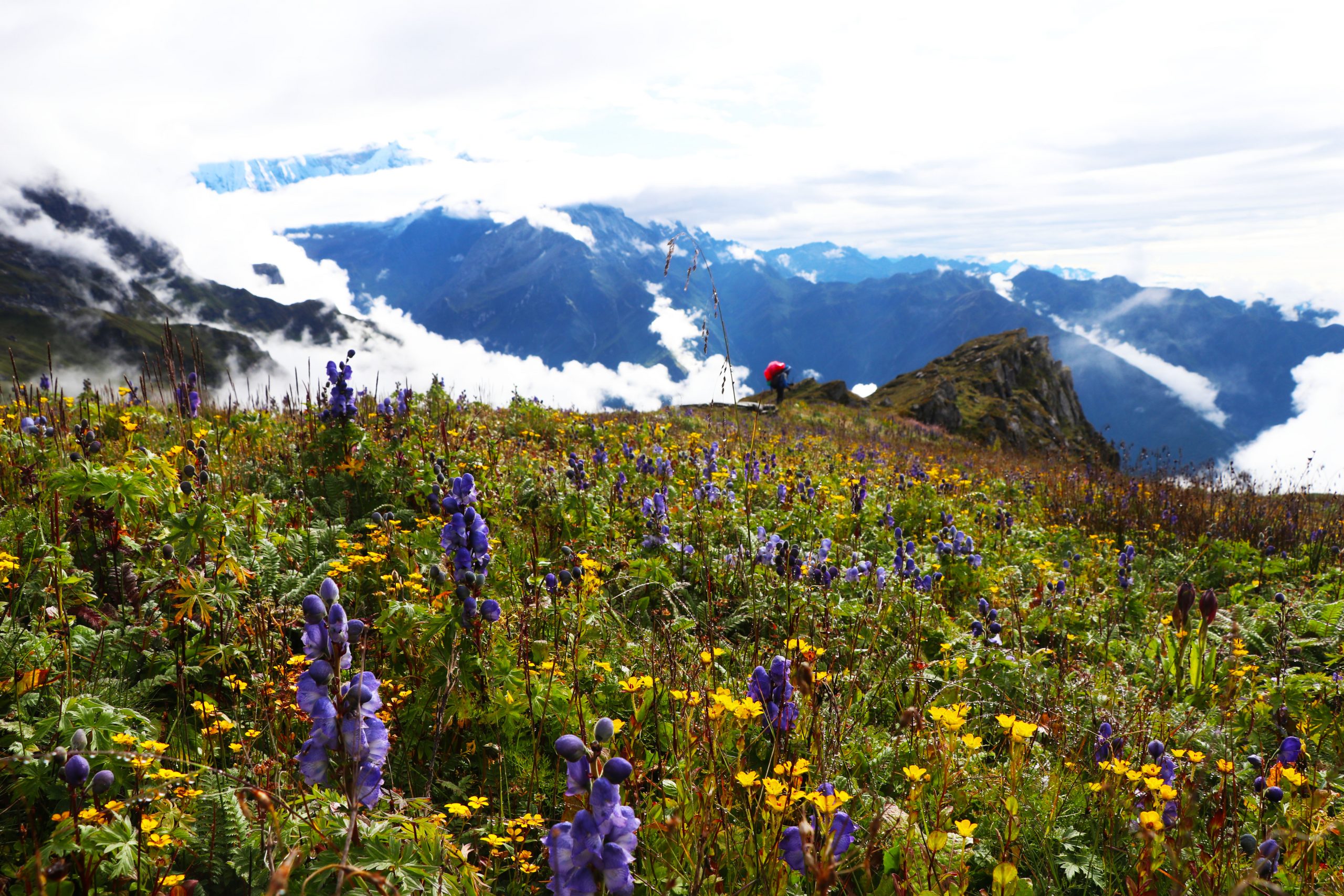
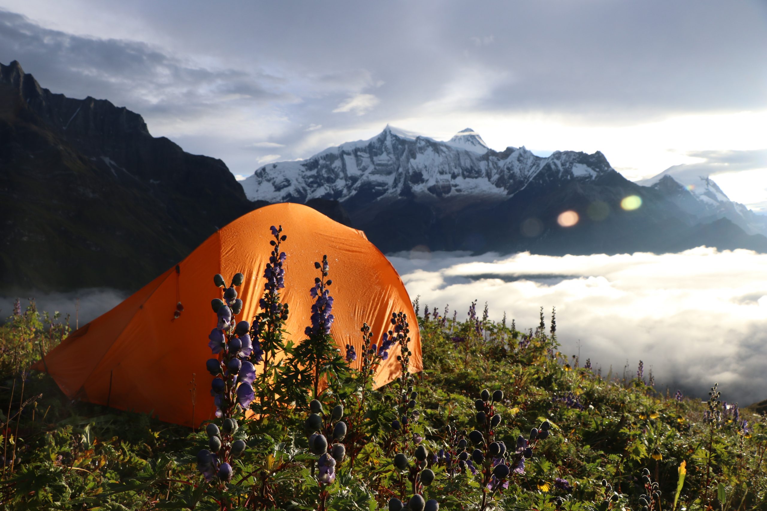
From this pass turn left and descend slightly along the grassy foothill of Thulo Bukeni. This may take about 1½ hrs.Go on for 15-20 more min and you will join the official trail to base camp and continue your journey. In 45-60 min, you come to Nauche Kharka (4,317m) which is a good place to camp. If you come here between mid-August and end of September, you will see a wide meadow of beautiful flowering Aconitum Spicatum plant (which is deadly poisonous). In the dry season there is no source of drinking water here, but a local expert can get from somewhere for you. According to what the local people told us, a bit further on after going under a cliff, water can be brought from a dry riverbed. Why have I said dry riverbed? The snow on the north-eastern side of Mardi Himal melts in the middle of the day and dries up at other times. In the dry season there is no source of drinking water; but the water that flows in the middle of the day collects in a corner of a riverbed or in a stone tank and can be brought from there.
Nauche Kharka to Mardi and Machhapuchhre Base Camp (4,403m; 1.8 hrs approx.)
After breakfast, walk on the flat and gently descend for 10 min and gradually climb up to the dried rivulet channel (4,343m). I mean to say a side river channel. Mardi’s north and east glacier ice melted water flows through it around mid-day. That takes ¾-1 hour. Cross it and turn left and continue climbing for another 40 min, to MMBC (4,403m).
You can easily pitch tent above MMBC. You can drink water from the stream I mentioned, but someone has to go ahead to get it by mid-day or you must hire a local expert. If you climb 10-15 min more to the ridge or view point you can see the whole southern face of Machhapuchhre including its glacier, the clear eastern face of Mardi and the mysterious landscapes to the south. You get even better views from the ridge located just to the south-east of MMBC. If you have enough time after pitching your tents and having lunch, you can spend a few hours walking towards MMHC (Mardi, Machhapuchhre High Camp) and then returning to camp. It is important to take drinking water with you.
MMBC to Bungkha Kharka (4,112m, 3½ hrs approx.)
You descend back to Nauche Kharka in 45-60 min. After another 45-60 min you reach a place where you will find monsoon water springs. Continue 25-30 min and come to a wide meadow (4,200m) which is the lower part of Thulo Bukeni Kharka. After 5 min more you descend and cross water springs. You only hear the sound of it flowing under the large boulders. Keep walking an easy Nepali flat for 1 hour to come to Bungkha Kharka.
“Bungkha” in the Rai Kulung language means a flower garden or field; bung = flower, kha= garden or field. The best time to come here is in the monsoon, when you can see hundreds of kinds of flowering plants. This Thulo Bukeni area is one of the widest meadows I have ever seen in the Himalayas of Nepal. On a clear day, the views are just awesome!
You now have two options for your journey:
Option 1 is turning left and descending to Pipar, Karuwa the Ghachok area and driving back to Pokhara.
We chose option 2 as follows:
Bungkha Kharka – Korcha Danda (Korchung) (3,676m, 5 hrs approx.)
At Bungkha Kharka turn slightly right and climb for some min over the ridge. Turn left and continue along this ridge for 10-15 min to near some rock pillars which are trail signals. 10 min later there is another rock pillar and you soon cross Bagale Deurali (4,250m). Turn right here and gently descend towards Ekle Deurali (4,193m) in 20 min. From here after a few more min, descend and turn left and walk 25-30 min on a grassy steep reaching Sirka (Samarkuko Dhad) (4,125m). Here you can pitch camp and find water with the help of an expert.
Hike down along this ridge for about 20 min; no clear sign of a trail; step from one rock to another and cross a little pass (4,070m) called Gorkhali Bajeko Linga. You have to hold on here while descending or ascending. After descending 10-15 min you come to a difficult path where you have to step from boulder to boulder; continue 30-40 min to Kasle Kharka (3,793m), a good camping place with mind- blowing views. We didn’t find water here, but we were told there are little springs somewhere near for herders.
After 25-30 min in abamboo and rhododendron forest, the trail comes to the top of a huge landslide area; you’re safe on the left side while going down. Keep on for 40-50 min of more descents and less ascents to a trail junction (3,595m). Take the right hand trail to come to Korcha Danda (3,676m); it took us 45 min. This is one of the most beautiful places on this trip. You have 360° gorgeous views including at least 10 different peaks and enough camping space here. If you’ve got time to spare, it’s worth spending an extra night here. We were told by local people about drinking water available somewhere around, but it may take 45 min to bring it.
Again, there are two options from here:
Option 1 is going to Khumai, Hile Kharka, Ghachok and driving to Pokhara.
But we took option 2;
Korcha Danda-Prundhu Village (1,757m; 5 hrs approx.)
At Korcha Danda turn right and make a long and steady descent along the ridge. Pawan and I were fit and did not stop to rest on the way. We reached Meshram (3,112m) in 1½ hrs. There is a community lodge with six rooms and a porter’s shelter available here and a piped water supply.
We continued walking down in the dense forest for 55 min and came to another shelter (2,700m). Then in 35 min we came to Naudhoke (nine-door) cave near a temple (2,550m). You go up from here about 10 min to a trail junction. Take the smaller path to the left.
By now we were tired, but the only option was to continue 1½ hrs to Kaltha Danda (1,950m). We soon entered Prundhu village (1,757m). As it was starting to get dark we decided to stay at one of the home stays. There are 6 home stays in total. Sahuni Didi made a delicious dal bhat for us.
Prundhu-Lumre 1,186m and drive to Pokhara (800m, 4 hrs approx.)
25 min descent to Takru (1,533m), a beautiful Tamang village. There are 12 home stays. Keep going 10 min down and come to another village called Emu with a few home stays. In 20-25 min you come to Saidighatta (1,319m). It’s located on the left bank of the Mardi Khola. Here there is also a Rainbow Trout fish farm owned by Bhakta Gurung, from where you can get fresh fish as you need and the dishes made from it.
8 min further on the dirt road is Kuibang village (1,308m) with at least 15 home stays. To be honest, I really love this place. There are very clean, old and beautiful houses. Many of them were damaged by the 2015 earthquake.
The final descent to Lumre bazaar took us nearly 1 hour, and from there the drive to Pokhara takes about 1 hr. A road is already constructed toTakru and Prundhu, but you can avoid it and still walk part of it with very little traffic.
My special thanks to Mr. Robert Beecham in England, who has helped to edit my article.
Itinerary Option A:
Day 01: Welcome in Kathmandu (1,300m)
Day 02: Explore Kathmandu
Explore in Kathmandu including UNESCO world heritage sites.
Day 03: Drive from Kathmandu to Pokhara (800m; 6-7 hrs approx.)
You can also take a 25 min flight to Pokhara, but driving with a tourist coach is cheaper and gives you a chance to see people lifestyles, villages etc.
Day 04: Pokhara to Lumre and trek to Takru village (1,533m; 5-6 hrs approx.)
Drive from Pokhara to Lumre bazaar (max 2 hours) and trek to Takru via Kuibang and Saidighatta. Overnight stay at home stays.
Day 05: Takru village to Metapurung (2,700m; 6-7 hrs approx.)
Today, you have a steady and tough climb in the forest. Bring packed lunch and drinking water with you. At Metapurung there is one porter shelter with 2 rooms. You can pitch 8-10 tents. Piped water is available.
Day 06: Metapurung to Korcha Danda (3,676m; max 4-5 hrs.)
Continual hard climb but with mind blowing views. Max 4 to 5 hrs depending on your fitness. While you’re at Korhcha Danda you will realize that all your effort was well worth it. You get brilliant views of both sunrise and sunset and at least 10 different snow peaks from one place.
Day 07: Korcha Danda to Bungkha Kharka (4,112m; 5 hrs approx.)
Today is probably one of the best days for beautiful scenery. Lots of climbing along the ridge but it’s less tough than previous days. Bring a packed lunch with you.
Day 08: Bungkha Kharka to MMBC (Mardi and Machhapuchhre Base Camp) (4,403m; 4-5 hrs max.)
An easy climb to Nauche Kharka and then a hard ascent to MMBC.If you don’t continue to Tin-shir (confluence of the Seti and its 2 tributaries Madi and Modi), this place will be the final destination for this trip. From here you get the closest view of Mardi Himal and Machhapuchhre.
Day 09: MMBC to Pipar Kharka (3,310m; 6-7 hrs approx.)
A short walk from MMBC up to the view point. Take photographs, have breakfast and continue the descent to Pipar via Bungkha Kharka. This takes 6-7 hrs. At Pipar there is a campsite and water is available.
Day 10: Pipar Kharka to Karuwa village (1,310m; 7 hrs approx.)
Continue the descent to Karuwa which has home stays and campsites. In the dry season you can take a jeep directly to Pokhara.
Day 11: From Karuwa trek to Tatopani (Kharpani) (1,210m) in about 1½hrs and drive to Pokhara (800m) in 1 hour.
An easy short trek to Tatopani where you can have a bath in the hot springs and then a bus/jeep drive to Pokhara.
Day 12: Explore in Pokhara
Many choices here: sightseeing, paragliding, boating, having massage therapy and much more.
Day 13: Pokhara to Kathmandu (1,300m; 6-7 hrs drive)
You have 2 options; if you’re short of time, take the 25 min flight or the 6-7 hrs coach drive if you prefer.
Day 14: Farewell to Kathmandu, Nepal.
Our representative will pick you up at your hotel and drop you at TIA airport.
Itinerary Option B:
Day 01: Welcome to Kathmandu (1,300m)
Day 02: Explore Kathmandu
Explore in Kathmandu including UNESCO world heritage sites.
Day 03: Drive from Kathmandu to Pokhara (800m; 6-7 hrs approx.)
You can also take a 25 min flight to Pokhara, but driving with a tourist coach is cheaper and gives you a chance to see people lifestyles, villages etc.
Day 04: Drive from Pokhara to Ghachok village (1,254m; 45 min – 1hr max)
Drive from Pokhara to Ghachok (1 hour max) where there are home-stays and camping sites. After arriving there you can walk round the village.
Day 05: Ghachok village to Hile Kharka (2,160m; 6 hrs approx.)
Today, you start your trek to Hile Kharka where there is a nice camping site and water available.
Day 06: Hile Kharka to Khumai (3,245m; 7hrs approx.)
Continual hard climb but with mind blowing views. Max 4 to 5 hrs depending on your fitness. Next morning while you’re at Korhcha Danda you will realize that all your effort was well worth it. You get brilliant views of both sunrise and sunset and at least 10 different snow peaks from one place.
Day 07: Khumai to Korcha Danda to Bungkha Kharka (4,112m; 6-hrs approx.)
Today is probably one of the best days for beautiful scenery. Lots of climbing along the ridge but it’s less tough than previous days. Bring a packed lunch with you.
Day 08: Bungkha Kharka to MMBC (Mardi and Machhapuchhre Base Camp) (4,403m; 4-5 hrs max).
An easy climb to Nauche Kharka and then a hard ascent to MMBC. If you don’t continue to Tin-shir (confluence of the Seti and its 2 tributaries Madi and Modi), this place will be the final destination for this trip. From here you get the closest view of Mardi Himal and Machhapuchhre.
Day 09: MMBC to Pipar Kharka (3,310m; 6-7 hrs approx.)
A short walk from MMBC up to the view point. Take photographs, have breakfast and continue the descent to Pipar via Bungkha Kharka. This takes 6-7 hrs. At Pipar there is a campsite and water is available.
Day 10: Pipar Kharka to Karuwa village (1,310m; 7 hrs approx.)
Continue the descent to Karuwa which has home stays and campsites. In the dry season you can take a jeep directly to Pokhara.
Day 11: From Karuwa trek to Tatopani (Kharpani) (1,210m) in about 1½hrs and drive to Pokhara (800m) in 1 hour.
An easy short trek to Tatopani where you can have a bath in the hot springs and then a bus/jeep drive to Pokhara.
Day 12: Explore in Pokhara
Many choices here: sightseeing, paragliding, boating, having massage therapy and much more.
Day 13: Pokhara to Kathmandu (1,300m; 6-7 hrs drive)
You have 2 options; if you’re short of time, take the 25 min flight or the 6-7 hrs coach drive if you prefer.
Day 14: Farewell to Kathmandu, Nepal.
Our representative will pick you up at your hotel and drop you at TIA airport.


Contact Us
Prems Nepal Trek have been providing exceptional services since 2004 and satisfying the travel enthusiasts, providing all your need for travel and tour.
- Khapaudi,lakeside-6,Pokhara
- +977-9807380590
- premsnepaltrek@gmail.com